Somayeh Dodge recently gave a talk entitled “WhereNext: Towards a Cartographic Framework for Movement” at AutoCarto 2020 on Wednesday, November 18, 2020.
AutoCarto 2020 (cartogis.org/autocarto) was the 23rd International Research Symposium at the intersection of cartography and GIScience, presented by the Cartography and Geographic Information Society (CaGIS). The meeting was held virtually in an open access format. The theme in 2020 was WhereNext: “In this symposium, we not only look at where we are and where to go next, we also challenge the ideas of where and next in terms of meaning, communication, visualization, and reasoning in the new age of automation, robotic revolution, and artificial intelligence (AI).”
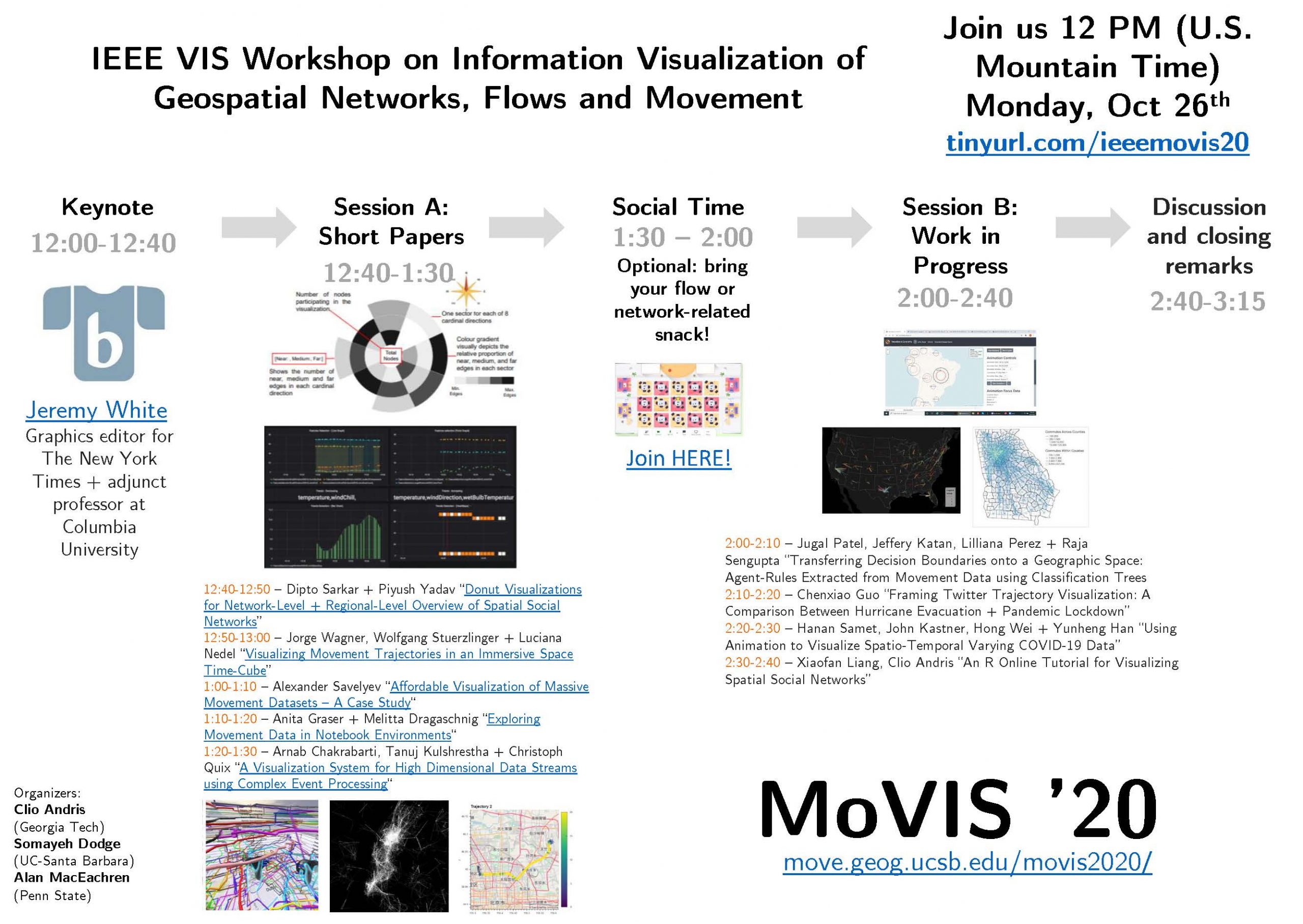
The full recording of the IEEE VIS Workshop on Information Visualization of Geospatial Networks, Flows and Movement (MoVIS 2020), held on October 26th, 2020, is now available to watch on-demand. View the recording here on YouTube.
Researchers frequently access and visualize data that represent spatial connections. These include GPS trajectories, migration movement, mobile phone-based movement, social networks, flights, commutes, SMS/phone call connections, human and animal movement trajectories, commuter flows, international trade, disease transmission flows, remittance flows, online friendship connections and transportation magnitudes. They are important in the study of globalization, wealth distribution, information spreading, epidemiological modeling, economics and infrastructure management. At the same time, analyzing these data requires advanced visualization methods. The objectives of this workshop were to explore the best ways to visualize large, spatio-temporal flow systems with both node and edge attribute data; describe the best visualization methods to unearth meaningful results; facilitate the use of diverse big data sets, communicate these results through visualization and description; and reflect upon how visualization is best communicated for urban and regional studies, geography, urban planning, public health, civil engineering, sociology and related fields.
The MoVIS ’20 workshop is situated in a larger body of research on geovisualization, geospatial data analytics and exploratory spatial data analysis (ESDA). This body of work includes mapping spatial datasets using different visual techniques, and assessing how humans interact and gain insights from spatial data. Spatial flow data is a special type of data that presents issues like the “haystack” problem of overlapping flows, edge effects, issues of using polygon centroids as origins or destinations, and issues of scale and modifiable areal units.
More info:
The MoVIS 2020 workshop was organized by Somayeh Dodge along with Clio Andris (Georgia Institute of Technology) and Alan MacEachren (Pennsylvania State University). Full program committee and more details about the workshop are available on the MoVIS 2020 page.
Modeling of the effects of NPIs in COVID-19 transmission
Browse visualizations here: covid19-mobility-vis
MOVE starts a new interdisciplinary collaboration with the UCSB Geography, Computer Science, Statistics and Applied Probability Departments, and the Information Systems and Modeling Group of the Los Alamos National Lab. The research is funded by VCR COVID-19 Seed Grants Program. The aim is to develop data-driven and knowledge-driven approaches to learn and model spatial and socioeconomic heterogeneity in exposure to COVID-19 and study the relationships between non-pharmaceutical interventions (NPIs) in terms of mobility and interaction and virus transmission at multiple geographic scales. Graduate students who are involved in this projects are: Evgeny Noi, Zijian Wan, and Vania Wang.
The MOVE@UCSB Laboratory at the Geography Department at UC Santa Barbara is seeking PhD students. We are looking for talented students with a strong quantitative background in GIScience, Geography, Computer Science, or Data Science, and interest in movement and mobility. Our group focuses on the study of movement using data science and geo-computational approaches, including movement data analytics, pattern mining, machine learning, geovisualization, -AI, modeling, and simulation. Please see our research areas for more information. The students will be engaged in multidisciplinary research to develop data science approaches to study movement in different contexts including human mobility, migration, health geography, movement ecology, and natural hazards and earth system sciences. Please find more information about the application process and the UCSB Geography Department here. The application deadline is December 15th, 2019. If you are interested in this opportunity, please contact Dr. Somayeh Dodge (sdodge[at]ucsb.edu) before submitting your application.
Somayeh Dodge has been awarded an NSF grant as the sole PI of the project “Visualizing Motion: A Framework for the Cartography of Movement” (NSF award # 1853681, amount $328,756). Evgeny Noi will be working on this project.
This project will examine how motion as a dynamic phenomenon, with complex space and time dimensions, is effectively represented in geographic visual displays. It will develop visualization methods and tools to map movement patterns and interaction between individuals.
Somayeh Dodge joined the Department of Geography at UC Santa Barbara in July 2019. She runs the MOVE@UCSB Lab with a main focus on data science research on analysis, modeling, and visualization of movement. If you are interested in joining MOVE@UCSB, please contact Somayeh at sdodge@ucsb.edu.